Mount Takorika Tracks
Last Modified: 27-9-2023 12:01
By: Christopher Cookson
© Christopher Cookson License this image
Mount Takorika is a 721 metre peak to the south west of Havelock, with a network of walking tracks through regenerating native bush, accessible directly from Havelock Township.
Getting There
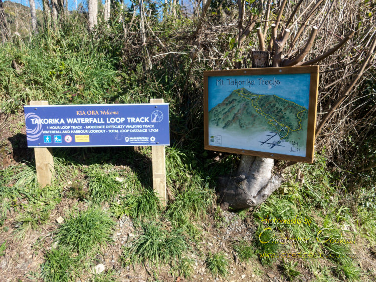
Access is from the western end of Lawrence Street, and also Inglis Street, both off State Highway 6. Free parking is available on the roadside at the end of Lawrence Street. Alternatively, it is only a few minutes walk from State Highway 6 through Havelock township, which has roadside parking.
Havelock Mens’ Shed have helpfully left a collection of hand made wooden walking poles at the start of the track on Lawrence Street, which walkers are invited to use, and return at the end of their walk.
Track Description
The network of tracks includes a short walk to a waterfall, which can be reached in under 20 minutes from Lawrence Street. All the various tracks and track junctions are clearly signposted with white painted signs with black text, and the Lawrence Street entrance has a hand painted sign with a map of all the various tracks.
A full circuit up to Mount Takorika and back down the ridge track will take several hours, however there are several link tracks along the way so that it is possible to complete a shorter loop.
The main tracks are well formed, although can be muddy in places. Although there is a continuous climb, it is not overly difficult. The track begins at an altitude of about 40 metres, and climbs to 721 metres at Mount Takorika, for a vertical climb of around 680 metres. By way of comparison, the Tirohanga Track in Picton climbs from about 20 metres at Garden Terrace to about 240 metres at the lookout point, while the Mount Vernon track in Blenheim climbs from about 50 metres to 422 metres, so Mount Takorika is the steepest climb from any Marlborough settlement, however the start of the track is also the closest to hospitality venues, so at the end of a walk it’s easy to enjoy refreshments if desired. Some of the link tracks are quite rough, and signs warn about their unformed nature. They can be steep and slippery when wet. The link track from the waterfall to the main Takorika track includes a section where a sturdy rope tied to trees is provided to provide support on a short, particularly steep, slippery section. Sturdy footwear that can tolerate getting wet and muddy is strongly recommended.
What You’ll See
The lower part of the track is through luxuriant regenerating temperate rainforest with tree ferns and a variety of native trees. The small waterfall is a feature that can be visited with just half an hour to spare.
If you have more time, the track climbs away from the stream through mixed native forest, with māhoe the dominant species in damper areas with stands of kānuka on drier slopes. Unfortunately some sections of the track pass through areas of barberry and gorse; evidence that the bush here is regenerating from past damage and invasive species.
As the track climbs, the vegetation opens out to give fantastic views of Havelock and Te Hoire/Pelorus Sound.
Dogs
Dogs are permitted on leash. If you take a dog, you need to have it well under control, as there are slippery sections of track where a dog straining on its leash could cause its owner to slip. Also the area is rugged with dense bush cover and weka, so if a dog gets loose, it may be difficult to recover it if it decides to chase weka.
Key Information
Difficulty: Easy to Moderate
Walking time: 20 minutes to 4 hours
Maximum altitude gain: approximately 680 metres
Dogs: Yes, on leash
Images

View from Takorika Track
© Christopher Cookson License this image
Cite this page
Cookson, C. (2023). Mount Takorika Tracks. Retrieved April, 28, 2024, from https://www.marlboroughonline.co.nz/marlborough/information/recreation/tramping-and-walking/mount-takorika-tracks/