Queen Charlotte Track
Last Modified: 20-2-2019 19:32
© Christopher Cookson License this image
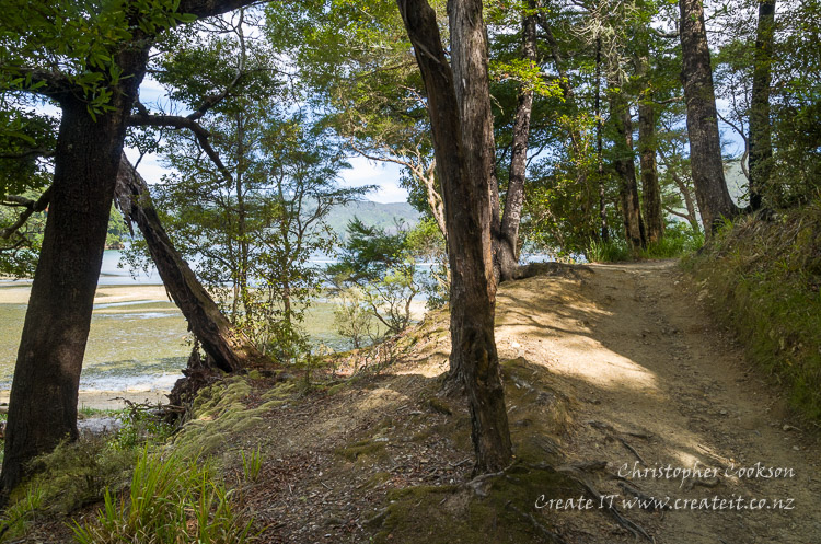
The Queen Charlotte Track extends over 70km from Ship Cove to Anakiwa in the Marlborough Sounds. It is promoted as one of the premier visitor activities in Marlborough due to historic and natural values of the area the track traverses and the unique scenery of the Marlborough Sounds. The track also forms part of Te Awaroa, a 3000km long walking trail that spans the length of New Zealand The track passes through areas of native rainforest with mature trees hundreds of years old. In these forests native wildlife is prolific. During the day tui, bellbirds and kereru feed in the canopy while at night weka emerge on the forest floor and morepork call to each other across the forest. Along the track are various lookout points over Queen Charlotte Sound, and the track passes through a number of bays suitable for swimming or fishing.
History
Queen Charlotte Sound (Tōtaranui), holds a special place in New Zealand history, as the location of the first significant interaction between Europeans and Māori, during Captain James Cook's visit to Ship Cove in 1770. In the 1980s, the Commissioner of Crown Lands proposed a track along Keneperu Ridge. Although parts of the land were in Crown ownership, significant areas were privately owned, however land owners enthusiastically embraced the concept, and their involvement lead to the first walkable track in 1983, however lack of government funding stalled progress for several years. With the formation of the Department of Conservation (DOC) in 1987, work on improving the track gathered momentum, however significant work was required following several years of neglect. Improved, and finally completed, the Queen Charlotte Track was formally opened in 1991.
Walking the Queen Charlotte Track
According to DOC, the track can be completed on foot in 3-5 days, or on mountain bike in 2-3 days. In addition to the main track, various shorter walking tracks branch off the main Queen Charlotte Track. The track is generally divided into six stages with accommodation and services available at the end of each day. It is possible to walk only parts of the track, or for those with a high level of fitness, complete the entire track in fewer days. Various companies offer guided trips and pack carriage to those who wish to travel light. It is possible to start at either Anakiwa or Ship Cove but if walking from Anakiwa it pays to arrange transport from Ship Cove in advance because camping is prohibited.
Parts of the track cross private land, while other sections cover land administered by the Department of Conservation (DOC). A pass is required for the sections on private land.
Camp sites and private accommodation are available along the track, and various tourist operators provide guided walks. Transport operators provide land and sea transport to and from start and end points of the track.
Track Sections
Ship Cove - Resolution Bay
This is about 4.5 kilometres and takes 2 hours. The track passes through lush forest climbing over a saddle into Resolution Bay where there are cabins for walkers wishing to spend the night.
Resolution Bay - Endeavour Inlet
Even though being around 10.5 kilometres long this section only takes 3 hours. There is a small amount climbing but most of it is flat. Much of the track is through native forest but towards the head of Endeavour Inlet there is farmland and two lodges offering accommodation and restaurants facilities.
Endeavour Inlet - Camp Bay
This 11 kilometre section takes 4 hours and leads through regenerating bush to the West side of Endeavour Inlet. There is a camp site at Camp Bay and cabins at Punga Cove.
Camp Bay - Portage
This is the longest and most demanding section being a total of 20 kilometres and taking 9 hours. However, it is well worth it as the views of the Sounds from the ridge are truly breathtaking. Water and toilets are available at several points along the way. There is accommodation and a restaurant at the Portage and a camp site at Cowshed Bay.
Portage - Mistletoe Bay
Much of this 8 kilometre section is through regenerating bush along the ridgeline. It takes about 3 hours. There are camping facilities at Mistletoe Bay and accommodation at Te Mahia on the other side of the ridge.
Mistletoe Bay - Anakiwa
This last section runs along the coastline through regenerating bush and finally through tall mixed forest. It is 12.5 kilometres long and takes about 4 hours. Anakiwa has accommodation and phone services available but it pays to book travel services in advance.
Web Links
Cite this page
Queen Charlotte Track. (2019) Retrieved April, 25, 2024, from https://www.marlboroughonline.co.nz/marlborough/information/recreation/tramping-and-walking/queen-charlotte-track/