Lake Chalice
Last Modified: 16-7-2021 23:41
By: Christopher Cookson
© Christopher Cookson License this image
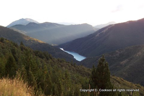
Lake Chalice is the northernmost lake in the east of the South Island, the only lake in the Mount Richmond Forest Park and one of a handful of freshwater lakes in Marlborough. It formed approximately 2000 years ago when a huge landslip from Old Man, possibly caused by a large earthquake, dammed the upper Goulter River. The landslide rubble rises at least 15 metres above the lake level. Evidence of this are the many stumps on the lake bottom. There is no outlet to Lake Chalice so water drains through the landslip rubble into the lower Goulter River. The lake itself is about 2km long, and about 200m wide. Because of its location surrounded by steep mountains and relatively high altitude of over 700m above sea level, the lake is cold even in summer, so may not be ideal for swimming.
Fires in European times burnt some of the forest cover but most of the landscape around the lake remains fully forested in native beech forest. A variety of native flora can be found around the lake shore including species of Hebes, Crassula, and the rare Centipeda aotearoana (NZ Botanical Society 2011) . Wilding conifers, particularly douglas firs have been spreading above the lake, on the southern side. The lake has only one species of fish, kōaro or Galaxius brevipinnis with this population scientifically important as they have been geographically isolated since the formation of the lake. Originally, blue duck (whio) and kākāriki could be found in the area. (Walrond, C.)
There is no direct road access to Lake Chalice, however there is access via walking track. Access is via the Northbank Road, off State Highway Six, a few kilometres north of Renwick. From the start of the Northbank road to Top Valley is a drive of approximately 40km, the last few kilometres on gravel road. Top Valley provides the most convenient access to Lake Chalice, as it is possible to drive up the Mount Patriarch road to a carpark a few kilometres above the lake. Unfortunately this road is frequently closed during working hours as a result of logging operations in the area. In dry weather, access is possible with a normal vehicle, but in wet weather, a four wheel drive is essential.
References
Walrond, C. (n.d.) Place Maker Retrieved from https://www.nzgeo.com/stories/place-maker/
New Zealand Botanical Society (2011). Newsletter No. 104 June 2011 Retrieved from http://www.nzbotanicalsociety.org.nz/newsletter/nzbotsoc-2011-104.pdf
Cite this page
Cookson, C. (2021). Lake Chalice. Retrieved April, 20, 2024, from https://www.marlboroughonline.co.nz/marlborough/information/geography/lakes/lake-chalice/