Geology of Marlborough
Last Modified: 21-2-2019 7:50
 Marlborough is a region shaped by powerful geological forces. The Alpine Fault which follows the plate boundary between the Australian and Pacific plates passes through the region, and many smaller faults also contribute to the shape of the landscape. In the past, glaciation has also contributed significantly to the shape of Marlborough.
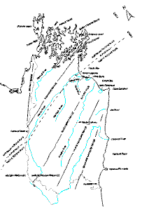
In the south-east, along the Pacific coast, the Seaward Kaikouras loom steeply. Formed by ongoing, and geologically rapid uplift, on their inland side they are separated by the Clarence Valley from the Inland Kaikoura chain which culminates in spectacular 2885-metre Tapuae-O-Uenuku. North-westwards again appears the Awatere Valley, followed by the Black Birch range system and then the Wairau Valley. Finally, just across the Wairau fault angle depression in the far north-west, lies a double range block, spreading 'V'-fashion towards Cook Strait. Arising in the south-west from an apex at Tophouse Saddle, the eastern arm of the 'V' is the Richmond Range fronting the Wairau Valley. The western arm, the Bryant Range, overlooks Nelson Province. This 'V'-shaped mountain block steadily diverges and decreases in height until finally ending in the outermost capes of the Marlborough Sounds.
By way of explaining the formation of the Sounds, imagine long ago the above-mentioned 'V'-shaped mountain block slowly sinking or tilting over on its Cook Strait side, thereby permitting the Pelorus and Queen Charlotte valleys to be drowned by the sea. Such as drowned river valley system is known as a ria. Both tilting and sinking of the Sounds and rising sea levels since the last ice age have contributed to their current form.
Viewed from the air or sea, Marlborough's saw-tooth mountain skyline stands in strong profile. Aligned south-west to north-east, jagged parallel ranges separate long straight valleys. Their parallel layout arises from a vigorous tectonic and geologically young past. Bulldozed forward by the westward-advancing Pacific Continental Plate, block-shaped ranges are still crumpling sky-wards as it jams into the Australian Plate barring the way. Clearly a zone of violent contact, Marlborough continues to experience frequent tectonic changes along major fault lines.
The South Island's renowned Alpine Fault traverses the length of the Wairau Valley. The pattern of the rock structure north of the Fault in Marlborough is mirrored on its south side in far distant Otago. This informs us that long ago north Marlborough broke away from Otago's strata and subsequently slowly crunched sideways some 500 kilometres along the line of the Alpine Fault. Within each of Marlborough's long valleys east of the Alpine Fault, lies a shorter, resident fault line. This tectonic scenario has resulted in many serious earthquakes in the past, notably the disastrous land upheavals of 1848 and 1855.
(extracted from Marl. Hist. Soc. Click ~ A Captured Moment, 2005)
Cite this page
Geology of Marlborough. (2019) Retrieved April, 20, 2024, from https://www.marlboroughonline.co.nz/marlborough/information/geography/geological-overview