Ward Beach - Marlborough's Limestone Coastline
Last Modified: 22-3-2021 17:15
By: Christopher Cookson

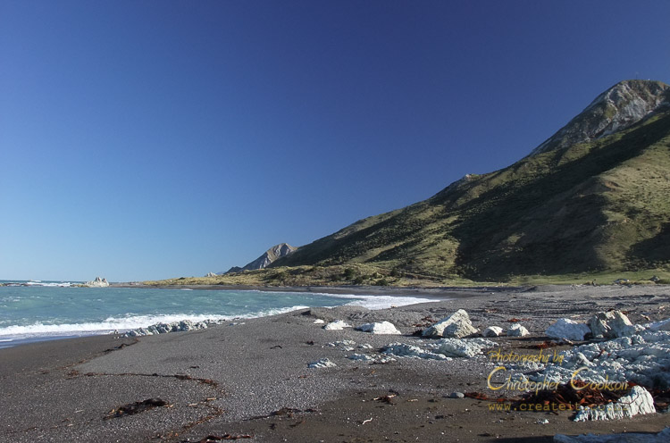
View south towards Needles Point subsequent to Kaikōura earthquake.
© Christopher Cookson License this image
Ward Beach provides access to Marlborough’s limestone coastline is an area of geological and ecological significance in south Marlborough, ranging from Chancet Rocks in the north to Needles Point in the south. Ward Beach is a gravel beach surrounded by limestone outcrops on Marlborough’s south east coast at the mouth of the Flaxbourne River. The area is a reserve with car park, public toilet, and a picnic table. The area is exposed to high winds, with a small wind farm located just over a kilometre away near Weld Cone. As a result of strong winds and wave motion, the beach is not suitable as a swimming beach.
Chancet Rocks
The Chancet Rocks are a coastal limestone outcrop about a kilometre north of Ward Beach. The area is designated as a scientific reserve.
Needles Point
Needles point is a coastal limestone outcrop about three kilometres south of Ward Beach.
Earthquake Geology and K-T Boundary
Following the 2016 Kaikōura earthquake, significant uplift of 2.2–2.6m occurred at Ward Beach exposing sedimentary rocks from the Cretaceous-Paleogene (K-T) boundary, approximately 66 million years ago, when a major mass extinction event occurred, ending the age of dinosaurs. The K-T boundary is a thin layer of dark grey clay in sedimentary rocks with a highly elevated level to normal of the rare element iridium, caused by a massive meteorite impact that left global fallout. The best place to observe the K-T boundary is about a kilometre north of Ward Beach at the Chancet Rocks reserve, which can be reached by walking from Ward Beach.
At Ward Beach itself, uplift from the earthquake exposed small dolomite (a calcium and magnesium carbonate mineral) concretions, similar in appearance, but smaller than the famous Moeraki Boulders on the Otago coast.
About three kilometres to the south, Needles Point is another area of geological interest, accessible via the beach.
Natural History
To the north of Ward Beach at Chancet Rocks, a New Zealand fur seal colony uses the beach, while a variety of shore birds can be found in the area including gulls, shags, terns, variable oystercatchers, and banded dotterels. Kelp and other marine algae are found in the sea, while a variety of nationally endangered plants are found on shore including mat daisies sand tussock, and pingao.
Commercial Use and Controversy
The beach is used as a launching site by commercial crayfishing company Burkhart Fisheries, based in Ward, however following the earthquake, the amount of uplift prevented the company from launching their boats in their previous location, and the company proposed creating a track along the beach to a more suitable site to the north, however this was opposed by conservationists concerned about the threat to endangered species.
Images
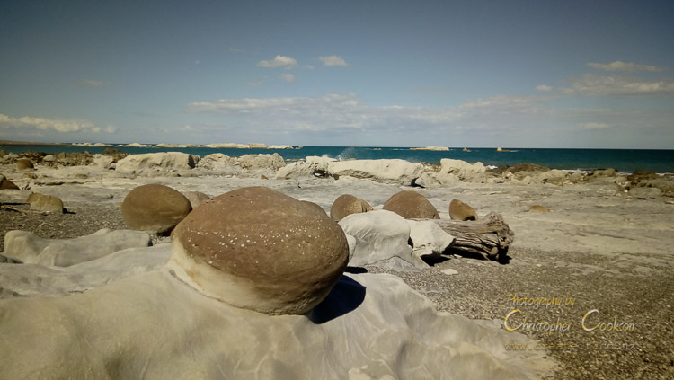
Concretions exposed by earthquake uplift.
© Christopher Cookson License this image
Prior to 2016 earthquake. Note rocks near surf with only small amount exposed compared to later photo.
© Christopher Cookson License this image
Web Links
Cite this page
Cookson, C. (2021). Ward Beach - Marlborough's Limestone Coastline. Retrieved April, 19, 2024, from https://www.marlboroughonline.co.nz/marlborough/information/geography/coastal-areas/ward-beach/