Mission to 'Mars' - A Journey to the Red Hills
By: Christopher Cookson
Last Modified: 3-11-2021 18:57
© Christopher Cookson License this image
My ten year old daughter came running to me on Sunday morning, full of enthusiasm.
“Dad, can we go to Mars?”
That particular Sunday was the annual church picnic, and normally we wouldn’t miss it for anything, but my wife seemed lacking her usual enthusiasm for church, as this was Marlborough Anniversary weekend and the last long weekend before Christmas. For the last few years, a good deal of our holidays had ended up being ‘working holidays’, helping my parents. My wife’s idea of a good holiday was somewhere with good food, a comfy bed, and nothing to do, however although the food bit always appealed to me, the other two were not so essential, and the thought of nothing to do was downright terrifying. Although my wife was extremely dubious, I consented to my daughter’s request, and quickly located packs, sleeping bags, and of course for me, copious quantities of photographic equipment.
I’d better clarify at this point, that our trip to ‘Mars’, wasn’t a case of signing up to become the Space Family Robinson on one of Elon Musk’s Starships to become colonists on another planet. It was rather closer to home, and didn’t even require leaving the confines of Marlborough, although it would certainly be an adventure, and did involve travelling to a location that was hostile to many forms of life.
At the western end of the Richmond Range, near the boundary between Marlborough and Tasman Districts, there’s a barren looking, flat topped ridge that gradually becomes more rugged and steep towards its north eastern end, with 1791 metre high Maungakura or Red Hill, the highest peak in the Richmond Range. The Red Hills get their name from the rich minerals in the rocks, which are also toxic to most plant life, resulting in the barren appearance of much of the area, with some parts indeed looking like a Mars-scape.
The weather forecast wasn’t the best, with a possibility of showers, but heavy rain wasn’t predicted, and I knew from the map that there were no river crossings, and only a few small streams along our route, so with good windproof and rainproof gear I wasn’t worried. We had our packs ready in record time, with me with the largest pack, carrying a good deal of the food, cooking equipment, lighting, first aid kit, toilet paper, water, in addition to my sleeping bag, while my daughter carried a middle sized pack that had just enough space to fit spare clothes and snacks in addition to her sleeping bag, while my wife carried a ‘day pack’ with only enough room for sleeping bag and water bottles. My daughter insisted she wanted to carry the larger pack, as she wanted to have the snacks with her. Something I’d learnt from the last overnight tramp with my daughter was that children can achieve anything so long as chocolate is involved.
With everything loaded into the car, we set off up the Wairau Valley along State Highway 63, with the peaks of the Richmond Range rising up parallel to us. By the time we got to the Branch River, the Red Hills were clearly visible on the other side of the river to us, standing out stark and barren compared to the bush clad Richmond Range. Crossing over the Wairau River at the Wash Bridge, the Red Hills loomed large above us, running parallel to the road.
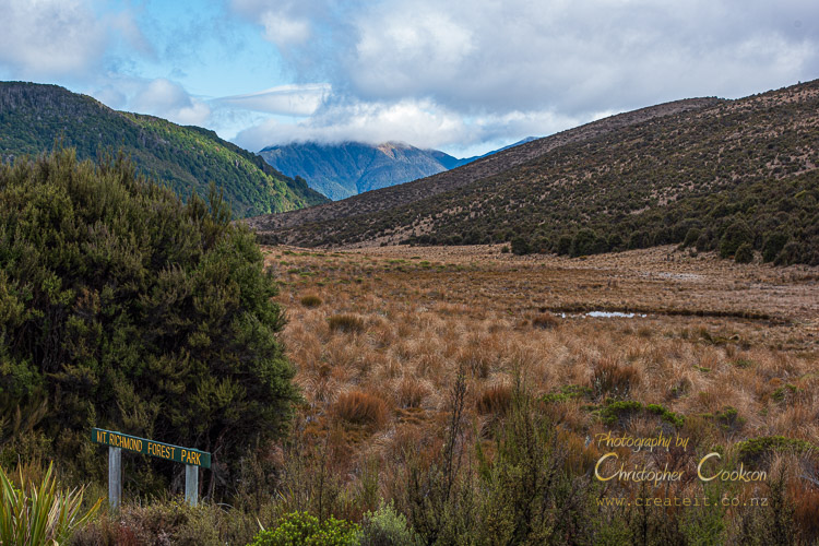
Reaching the end of the flat section of road, we crossed over the rather unoriginally named Six Mile Creek to where the road began to climb to leave Marlborough on the way to Lake Rotoiti. To the right of us, the barren Red Hills had been replaced by the green of tall beech forest, and then with little warning, a DOC sign advised where to turn off the road to the Red Hills Track. Anyone in a hurry could easily have missed the sign, but knowing the location, I’d already slowed down, so that we turned off the road into the car park under mature beech forest, after about an hour’s drive, where we had a sushi lunch before starting our tramp.
A DOC sign indicated between one and three hours to the hut, but with my daughter having about the size, and appetite of a hobbit, I knew that the more pessimistic estimate was likely to be more accurate, by the time all the snack breaks had accumulated.
The air was cool, and there was a good breeze blowing, so we quickly decided that wind proof jackets were essential. I changed into my tramping boots, my daughter double checked that she had all the snacks, especially the chocolate and beef jerky, and we were off. I had a suspicion that if someone invented chocolate coated beef jerky, my daughter would probably enthusiastically eat it, since the usual protein rich substances regularly coated in chocolate, namely nuts, provoked an anaphylactic reaction in her, however no matter how ecologically incorrect it might be, she was a cheerful little carnivore.
I was a little apprehensive, as there was a large van in the car park, and it looked as though it could accommodate a large number of occupants, however on closer examination, I noticed it did not have many seats, but a lot of space in the back, and the track sign indicated that the track was also used by mountain bikers, so this quickly allayed my fears of a full hut, as it didn’t look like anyone else was tramping.
A stroll in the deep, dark wood
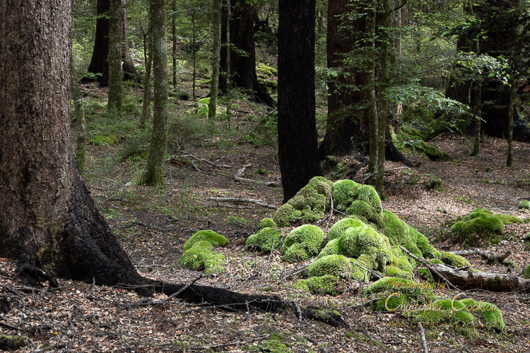
© Christopher Cookson License this image
We set off through the mature beech forest, giant black trunks rising to a canopy high above us, and mossy mounds on the forest floor. A large, fallen trunk with a diameter of about a metre had recently been chainsawed, as it had fallen across the track, but DOC rangers had obviously been out and about. We could hear the chatter of a stream, and after just a few minutes walk, came to a stream crossing, however it turned out that there was no need to get our feet wet, as a series of concrete posts had been laid parallel to each other in the stream bed to form stepping stones, but in a form that would also be easily negotiated by mountain bikers.
As we proceeded through the forest we met a sole tramper passing in the other direction, and I asked him whether he’d seen any other trampers. He hadn’t, and said He’d been walking for some days from the Pelorus River. Much later, I looked at a map, and worked out that he must have walked at least eighty kilometres by the time he got out of the bush, which would exceed all but one of New Zealand’s Great Walks. A bit further on we were passed by several mountain bikers who I assumed were associated with the large van in the car park. From then on, we had the place to ourselves.
A cottage in a clearing
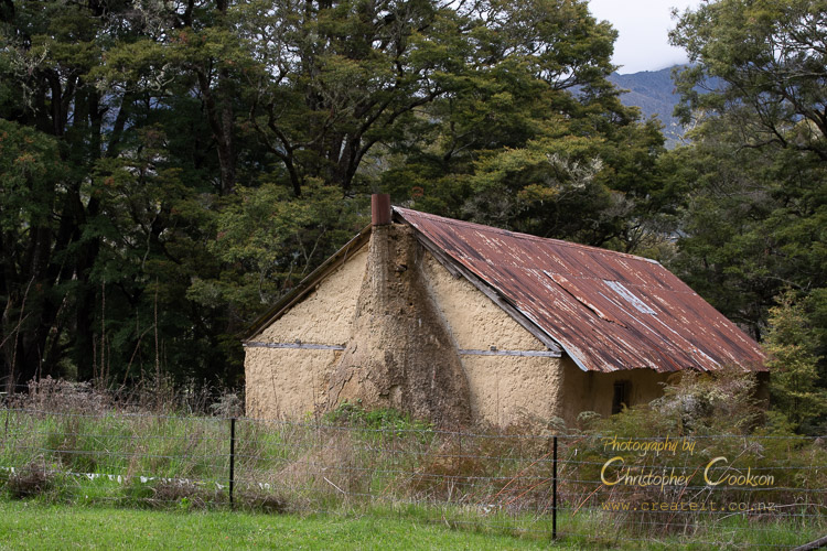
© Christopher Cookson License this image
After a while walking in the deep forest, through a few twists and turns and rises and descents, we came to the forest’s edge near where a fence separated it from a grassy paddock, and a derelict cob cottage. From here, the narrow walking track changed into a wide four wheel drive track, that evidently was rarely used by vehicles, given the vegetation growing in the middle of the track. From here, the track rose steadily at a gentle gradient, passing in and out of beech forest and mixed kānuka, kāpuka/broadleaf, and horoeka/lancewood forest in more open areas. Where the beech forest was most luxuriant we could smell honeydew. Numerous varieties of ferns grew alongside the track in the shadier areas, and at one point I got quite excited when I found a native orchid in flower beside the track. Under the more open kānuka forest, large clumps of coral lichen and mosses created an almost other worldly appearance. We heard the occasional korimako/bellbird.
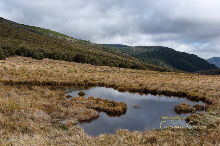
Somewhere over the Rainbow

Storm clouds over the upper Wairau and Rainbow Valleys
© Christopher Cookson License this image
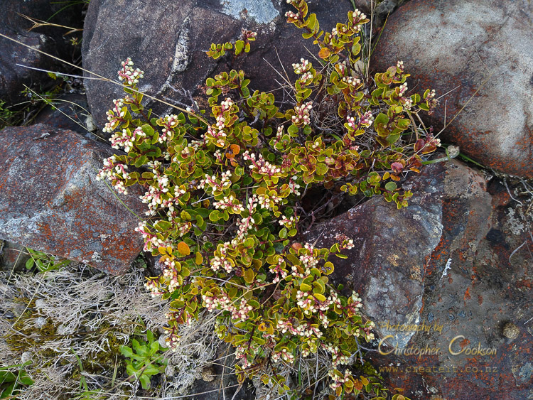
The weather was quite temperamental, with the sky constantly changing between bright sun and spots of rain, but with good jackets it didn’t really bother us, although deciding whether to keep them on or take them off became a bit of a challenge with the constantly changing conditions. As we got higher, we increasingly passed through areas of low vegetation so that we could look away to the south west to the upper Wairau where it wound its way between the Raglan and St. Arnaud ranges. Higher still, the trees began to give way to low growing alpine scrub, and other alpine plants including a multitude of small white New Zealand everlasting flowers alongside the track and in open areas amongst the scrub.
Rocky road

© Christopher Cookson License this image
The track became quite rocky, and began to take on an orange red colour that gave the hills their name, and if it weren’t for the vegetation, would have looked quite Martian. Not all the rock was reddish though, and we passed areas where shattered rock with an intense green colour littered the track. We hadn’t stumbled on a poorly known source of pounamu, instead, it was olivine, an igneous rock, not found in the rest of the Richmond Range, but part of the volcanic rocks of the Red Hills that are a testament to the massive geological forces in action at the plate boundary that runs through New Zealand.
I think there must be a Murphy’s Law of Tramping that the steepest part of any track will be near the end when you are tiredest. That was certainly the case here, although ‘steep’, was relative, as there are parts of the Wither Hills track to Mount Vernon that are considerably steeper, however since that track is within walking distance from home, we wouldn’t carry full packs with food and sleeping bags. In fact, since the car park was already above 500 metres altitude, and our destination was at 910 metres, our total climb was actually less than climbing Mount Vernon, but stretched out over nearly eight kilometres, instead of two, so really quite a gentle gradient, although the last 500 metres did cut across contour lines rather than follow them.
On top of the world
© Christopher Cookson License this image
It was clear now that we were in alpine country, with stunted vegetation, including all kinds of plants that we hadn’t seen at lower altitudes, with golden brown foliage more common than green. Bog pine, looking like a kind of prostrate cyprus was common, along with snowberries, and the strange looking Exocarpus bidwillii. A few scattered mountain beech trees tenaciously clung to survival, but largely the landscape was treeless. I couldn’t find common names for many of the species up here either in te reo Māori or English, suggesting that though beautiful, this was a harsh environment that few humans other than botanists frequented for long periods of time. Looking south, we had an excellent view of the upper Wairau, and were glad that we weren’t there, as dark, ominous rain bands obscured the St. Arnaud Range.
Cabin in the woods, or amongst a few trees at least
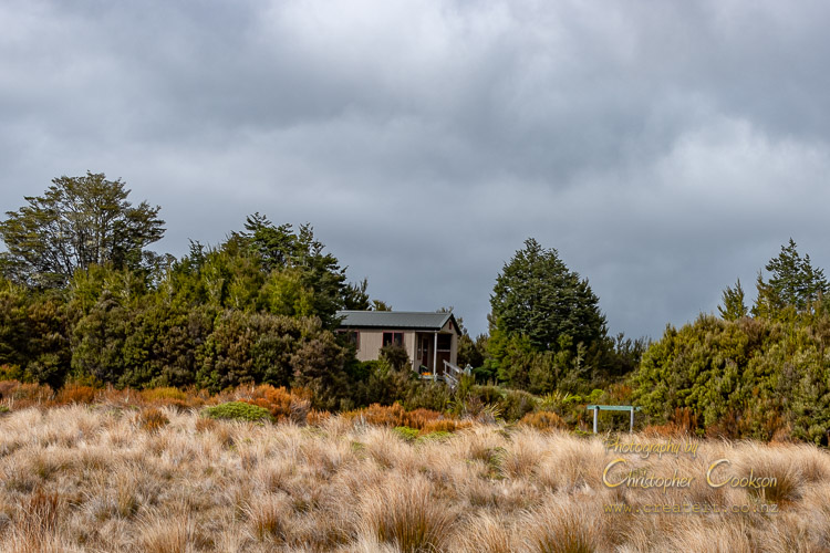
© Christopher Cookson License this image
The track led towards one of the few reasonable sized mountain beech trees, and behind it, we were suddenly at the hut, after about three hours of walking and snacking. It was a modern structure, looking like a tiny home perched on top of the mountain, double glazed, with shiny varnished plywood floor, a wooden deck to the north, six standard wooden bunks typical of DOC huts, a small wooden table, and a stainless steel bench. Even up here in the wilderness, there was a Covid QR code to scan. Although the double glazing kept the hut warmer than outside, there was no fire, and there were ventilation holes in the bottom of the door, so I didn’t think this was a place I’d want to stay in the middle of winter. Although the lack of a fire to make the hut cosy was disappointing, it did make sense, as there wasn’t much potential fuel around.
Reading through the hut book, a few people complained about the lack of a fire, while a lot of entries stated their pupose as TA SOBO. I guessed that TA stood for Te Araroa Trail, but the SOBO bit perplexed me till I arrived home to fine a timely article on The Spinoff website about Te Araroa, explaining that SOBO meant south bound.
Room with a view
© Christopher Cookson License this image
To the north of the hut we had a view out over a flattish, boggy basin filled with rushes, red tussock, and bog mingimingi, with two small tarns full of tadpoles. A few metres north of the hut, a yellow and green sign proclaimed that we were in Mount Richmond Forest Park. It probably also could have proclaimed that beyond that point was Tasman District, as the hut sat right on the boundary.
A track continued on beyond the hut to where it divided in two at some signposts. To the west, the Maitland Ridge Track led to Tophouse, while to the north, the Red Hills Track continued on to the Porters Creek Hut, about another four hours away. The sign also indicated that this was part of Te Araroa Trail, the 3,000 kilometre walking track from Cape Reinga to Bluff. Here in Mount Richmond Forest Park, it crossed in and out of Marlborough and Tasman districts, passing fifteen huts along the way, eventually emerging to civilisation in the north at Pelorus Bridge, then eventually connecting to Queen Charlotte Track via part of the Link Pathway. Just completing the Mount Richmond Forest Park section of the trail would be easily over a week’s tramping, but we were happy to say we’d stood on the trail rather than actually attempting it.
To the east of the hut, a fairly abandoned looking, deeply rutted and overgrown looking track led upwards to The Plateau, a large flat area at the western end of the Red Hills Ridge. I ventured a little way along the track, where I found scrubby vegetation had increased somewhat, with mānuka forming dense thickets to the sides of the track in places. The rapidly moving clouds periodically cleared giving way to blue sky and sunshine, with majestic views over the Wairau valley.
I had a bit of an explore with my daughter amongst the scrub, but before long she was asking when we were going to have dinner, even though it was only late afternoon.
Back in the hut, there was a set of playing cards, and Uno, so we sat and played a card matching memory game to use up a bit more time till it was late enough to realistically start thinking about dinner. We had freeze dried roast lamb and vegetables, along with two minute noodles for extras, knowing my daughter’s propensity to eat like a ravenous wolf when in the wilderness. She was keen to prepare dinner, which was rather convenient, as it basically involved boiling up water, adding it to the dry ingredients, and waiting a few minutes. The hut had a rainwater tank, but judging from the green algae on the down pipe where the water ran off the roof into the tank, the advice to boil water well before using it was to be taken seriously.
After dinner, I had a bit more of a walk around outside, but it was cold, and we were feeling tired, so in spite of daylight saving, we were all in bed by around eight o’clock. I had a Bible app on my phone, and since it was Sunday and we'd skipped church, I thought that we shouldn’t be completely heathen, and we didn’t have any hut companions to complain about us being too religious. I picked Psalm 148. The Bible seems to be full of references to nature as a living expression of the glory of God. In the Hebrew creation story, God took soil and breathed life in it to create Adam, while in the Māori creation story, it is Tāne who does the same thing to create a woman, Hineahuone, while there’s an evolutionary theory that clay minerals may have played a role in the evolution of life, so there seems to be broad consensus that we are descended from the earth. To me, spending time in nature is always a spiritual experience. I was born in Blenheim on the Wairau plain, so the eroded rock from these mountains to the west probably forms part of the soils where I’ve lived most of my life, and grown a fair amount of my own food, so it’s entirely possible, I’m literally made, at least in part, of these mountains.
My daughter, had initially been perfectly happy to claim a top bunk, but started complaining about wanting to sleep with one of us, which really wasn’t realistic given the width of hut bunks. Eventually the hut grew quiet, and we slept, at least to extent. My wife said the mattresses were hard and that I snored. I said that she snored. Given that snoring people don’t hear themselves snoring, we must have both slept at least part of the night, but we’d obviously both taken turns at disturbing the other. Our daughter didn’t complain about our snoring, but did say in the morning that the frogs in the tarns had been croaking all night.
Who's been eating my porridge?

© Christopher Cookson License this image
We woke to a cool, overcast day, but less windy than the day before. Breakfast was flavoured instant porridge, with some coconut milk to add flavour. Tramping with a daughter with nut allergy and dairy intolerance is interesting, as traditional scroggin mixes and muesli bars with nuts are out of the question, milk powder isn’t really an option either, and most alternative ‘milks’ come in heavy cartons. Fortunately, it’s possible to buy small tins of coconut milk that don’t add too much weight or bulk, and that worked well.
My wife and I had a cup of ‘prefabricated’ coffee each, and after packing up and tidying up it was time to say farewell to the hut, and begin our descent back to the car park.
After breakfast, the sky cleared somewhat, so that we could see the bush clad peak at the end of the valley to the north.
We all paid a visit to the ‘long drop’ before we departed, as although very unglamorous, a ‘long drop’ is still better than getting nature’s call on a rocky mountainside. I was glad I’d packed ample toilet paper, as 'long drops' are very much BYO in this regard.
All creatures great and small
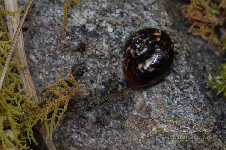
© Christopher Cookson License this image
The descent was uneventful, apart from my sharp eyed daughter spotting a tiny snail shell, that was some kind of native species I’d never seen before. Since we had plenty of time, I stopped frequently to photograph native plants, both those that I recognised, and those that I didn’t, so that I could submit them to the citizen science platform iNaturalist when I got home. We were passed by a grey haired mountain biker on an e-bike on his way down to the car park. Although I’m an older father, I thought to myself that if he were anything to go by, hopefully I’ve got at least another twenty years of adventures ahead of me still. We reached the car just after midday, so it was a fairly simple decision to drive the few minutes to Rotoiti to finish our adventure with lunch at the Alpine Lodge. Being a regular weekday everywhere but Marlborough, and Auckland under Covid restrictions, I’m sure the lodge was happy to have some customers. There seemed to be only a handful of customers there, but it certainly wasn’t empty. Sitting down to a hot meal at the end of our adventure was a nice way to return to civilisation.
Cite this page
Cookson, C. (2021). Mission to 'Mars' - A Journey to the Red Hills. Retrieved April, 19, 2024, from https://www.marlboroughonline.co.nz/marlborough/information/commentary/mission-to-mars-a-journey-to-the-red-hills/
Be part of the conversation
Sign up to post comments.