Exploring Marlborough by Bike
By: Christopher Cookson
Last Modified: 8-2-2021 15:10
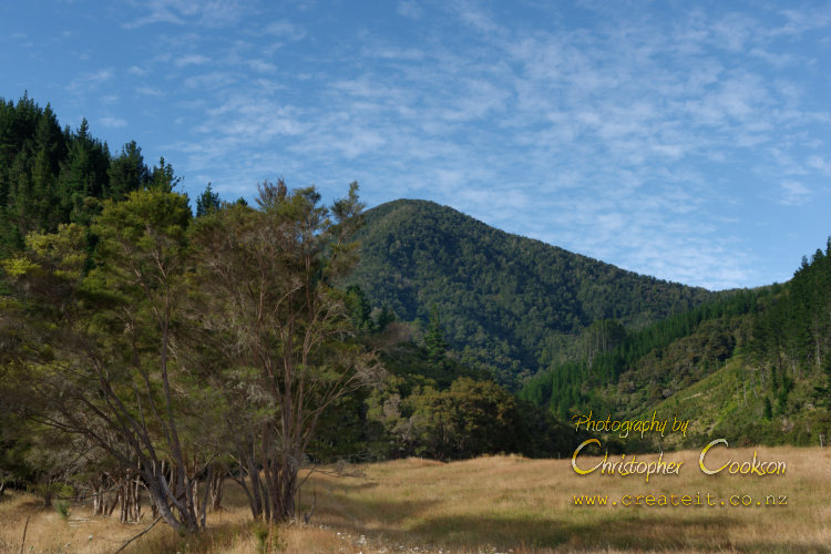
Start of Cullen Creek Walkway
© Christopher Cookson License this image
It’s a sunny February Sunday afternoon on Waitangi weekend, and this not overly fit middle aged male Marlburian decides to go for a bike ride. My daughter spent the night before vomiting, although she’s ok now, but she and my wife are not feeling like doing anything much, so in place of a Sunday drive, I’ll make it a bike ride instead. To be quite honest, Sunday drives and road trips in general might start becoming an endangered species if Kiwis start treating climate change like the existential threat it is. I’ll admit I’m a bit of a greenie, but I have vested interests, with clients across a range of Marlborough’s primary industries who probably aren’t greenies, but who certainly won’t thrive if Marlborough gets hotter, drier, and the sea gets more acidic. All that award winning Marlborough sauvignon blanc, the part that isn’t alcohol, is mostly water, and that water has to come from somewhere, and all imagine all those delicious greenshell mussels if they can’t grow shells.
With my environmental conscience, concern for the well being of Marlborough’s delicacies, and a little bit of middle aged growth rings around my middle that need some attention, I’ve decided to make it a mission in 2021 to see how much of Marlborough I can explore by bike. It’s a pretty daunting task, as there are parts of Marlborough so remote that I’ve never been to by car, let alone visiting by bike, but I’ll start where things are easy. The Wairau Plain is pretty flat, and unless you strike a particular blustery nor’wester or ‘beastly easterly’, you don’t need to be an Olympian to cover some good distances.
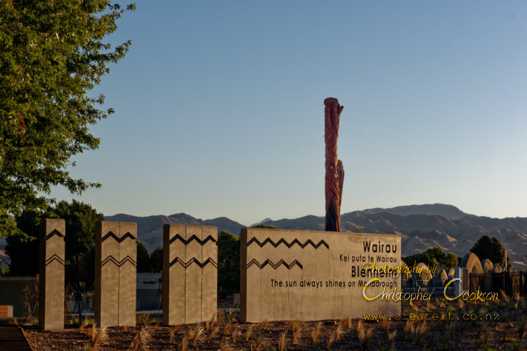
Today’s little expedition takes me out north through town over the historic Ōpaoa River bridge and along the cycle trail to Spring Creek. Last time I rode this track back in January, I arrived at the recently erected pou and rather optimistic sign welcoming people to the Wairau where the ‘sun always shines’ in the middle of pouring rain, but today the weather matches the sentiment of sign, however the temperature is comfortable on the bike, neither chilly, nor blistering heat.
The cycle trail out to Spring Creek runs alongside the railway line, and areas that were formerly a bit weedy now have well established native plantings and there are a couple of park benches along the way, probably more useful for walkers than cyclists, although families who want a rest might find them useful if kids find the distance a bit tiring.
At Spring Creek, the cycle trail ends, but I’m feeling good, so decide to keep going. I decide not to continue on State Highway One, as it is quite busy, but instead turn off through Spring Creek, over the Ferry Bridge, and then out to Marshlands and over the Wairau Diversion. Traffic here is lighter, so I feel a bit more comfortable as a cyclist. Immediately after the Diversion bridge, I turn onto Thomas Road that runs parallel to the Wairau Diversion and takes me back west towards Tuamarina.
At Tuamarina, I carefully cross over State Highway One and ride through Pioneer Place where there is a memorial to the variously named ‘Wairau Massacre’, ‘Wairau Affray’, or ‘Wairau Incident’, an unfortunate, and totally unnecessary fatal confrontation between Māori led by Te Rauparaha, and settlers led by Arthur Wakefield of the New Zealand Company. The location beside the Tuamarina River, with native vegetation including a tītoki tree that was used to tie up one of the Māori party’s waka, is tranquil today, and it’s hard to imagine the stupidity and arrogance on the part of the European party that even the settler administration of the day recognised subsequently, that led to bloodshed in this beautiful setting.
I am still feeling energetic, so decide to continue on my ride, crossing over the Tuamarina River, and continuing west along the Tuamarina Track. About five kilometres west of Tuamarina, I reach the turnoff to the Waikakaho Valley. I contemplate continuing along the Tuamarina Track to Kaituna, as I’d done in the opposite direction a few weeks previously, but I decide instead to explore the Waikakaho Valley, as I know the Cullen Creek Walkway through to Linkwater is located at the head of the valley, although surprisingly, after almost a lifetime in Marlborough I’ve never walked it. I have no intention of doing the walkway today, as it is already late in the day, and according to DOC the track takes five hours to walk one way, however I decide I can cycle to the start of the walkway. Mountain biking is permitted on the walkway, so maybe another time when I'm feeling fitter I might give this a go.
The Waikakaho Valley is about ten kilometres long, with sealed road for only the first few kilometres. Scattered homesteads with farms and lifestyle blocks are found along the bottom of the valley, while pine plantations cover the slopes of the steep hillsides. The Waikakaho River was mostly dry as I follow the valley, however occasionally there are sections with pools of water or even running water.
The road rises almost imperceptibly as I ride up the valley, but enough to increase the amount of energy I have to expend. After what seemed like an age, I finally reach the end of the road, and after passing through some farm gates which I carefully close behind me, I reach the start of the walkway. I pass through a tall gate that looks like it was designed to contain kangaroos, and I am amongst spindly regenerating kānuka forest, with small ferns and shrubs on the forest floor. For a short period of time this area, on both the Wairau and the Linkwater side had been the location of a gold rush, beginning in 1888, and sustaining the small town of Cullensville that survived until the early 20th Century.
Looking up at the rugged bush covered hills, and starting to feel a bit weary after my ride, I feel a great deal of respect for those prospectors who worked these hills, if they were lucky, managing to find a little gold, without the benefits of any modern technology, with transport limited to horses. The head of the Waikakaho Valley was probably a full day’s ride from Blenheim in those days, so making a return trip on my bike in an afternoon was probably a luxury those early pioneers could only have imagined.
After taking a few photos at the start of the track, it’s time to retrace my route back to Blenheim. I’m starting to feel a bit tired now, but fortunately returning down the valley is slightly downhill , so I don’t need to make quite so much effort. A couple of kilometres from the intersection with the Tuamarina track, a large black pig rushes out of the undergrowth along the side of the road and dashes along in front of me for about a hundred metres, before disappearing off into the vegetation at the side of the road.
Apart from the pig encounter, the return ride is uneventful, although I am feeling quite tired by the time I arrived at Tuamarina, so I decide to brave State Highway One and the bridge over the Wairau, rather than taking the detour out to Marshlands. There are some heavy trucks, presumably ferry traffic, on State Highway One, that I allow to pass before I cross over the road and ride south. I’m fortunate to arrive at the Wairau River bridge with no traffic, which is quite a relief, as the bridge is a little narrow, and being passed by a large truck on a narrow bridge isn’t the most pleasant experience on a bike. Once I’m over the bridge, I can relax, as there is plenty of room at the side of the road to keep out of the traffic, and once I reach Spring Creek, I can take the cycle trail the rest of the way to Blenheim.
I’m pretty exhausted by the time I finally make it home, with aching legs, and a slightly tender backside, however when I look at the trip statistics on the GPS app on my phone, I understood why. I’ve travelled just over 63Km in an afternoon; probably nothing for a regular hard core cyclist, but for an occasional cyclist on a mountain bike, quite a substantial ride. I'm somewhat thankful that I wasn't on an e-bike, as most seem to have a battery assist range limit of around 50Km, and having to pedal a heavy bike the remaining distance without assistance doesn't really appeal to me. Although I’m a bit sore, the scenery certainly beats a gym workout, and the cost is a big fat zero too. I’ll need a few days for my body to recuperate, which I can do as I work, but I’m already scheming for my next bike expedition.
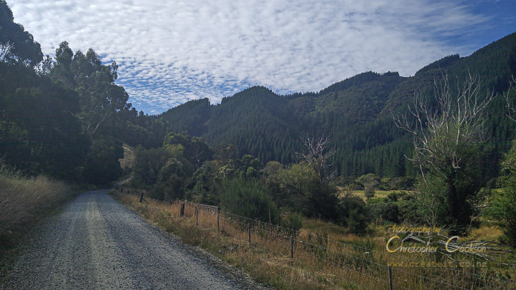
Beyond the first couple of kilometres the road is unsealed.
© Christopher Cookson License this image

Both trampers and mountain bikes are allowed, although if you're cycling, watch out for pedestrians.
© Christopher Cookson License this image
© Christopher Cookson License this image
Cite this page
Cookson, C. (2021). Exploring Marlborough by Bike. Retrieved April, 19, 2024, from https://www.marlboroughonline.co.nz/marlborough/information/commentary/exploring-marlborough-by-bike/
Be part of the conversation
Sign up to post comments.